Almaty District
Districts of Kazakhstan
This District occupies the whole southeast of the Republic, and its territory is called Zhetysu (Semirechye). It borders the Eastern Kazakhstan District in the north, and its boundary passes the following chain of large lakes: Balkhash, a massive fresh and salt-water lake; salt water lakes Alakol and Zhalanashkol, and fresh water lakes Sasykkol and Uyaly. The northern part of the District has a shallow slope to Balkhash Lake. It consists of a plain, the larger part of which is occupied by the Caryesyk-Atyrau, Taukum and Moiyinkum deserts.
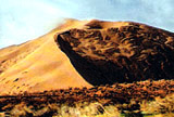
The vast Bakanas plain extends across the delta part of the Ili River crossed by ancient dry riverbeds. The Northern and Central Tien-Shan Mountain range, like an insurmountable wall, stands in the southeast, along the crests of which the border of Kazakhstan and China lies. The climate is extreme continental in the plains; precipitation is up to 300 mm per year. The climate is milder in the Ili foothills, thaws are regular, and precipitation reaches 600 mm. Vertical zones are clearly evident in the mountains.
There are deposits of gold, silver, ferrous and rare metals, phosphoric ore, potters' and refractory clay, construction materials, marble, granite, coal and more.
The Almaty oblast has distinct economic specializations: mainly engineering construction (machine tool construction, electronics, food processing, trade and catering equipment) and also tobacco, wine making, fruit and vegetables, sugar, confectionery, textiles and clothing; in the extraction of poly-metallic ores and production of batteries.
The diversified regional agriculture is based on irrigation farming and the use of rich natural pasture resources.
"Zhetysu" is the pearl of Kazakhstan, and implies seven rivers, running across that land and flowing into Lake Balkhash. It is a wonderful and unique land. Surprising secrets are kept by this land, known by the poetic name Zhetysu, where the paths and historical fates of many tribes and peoples crossed in the distant past.
The ancient culture of the Kazakh people has been reflected in priceless monuments from the past, i.e. stone sculptures and burial mounds; ancient city ruins also remind us today of the famous history of many generations of people in this land. Semirechye was an important center of farming and trade even in the Middle Ages.
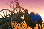
Part of the Great Silk Road, or the so called "Scythian steppe road", crossed the District; it is a unique complex of history, archaeology, monumental art, architecture and urban monuments, reflecting deep processes of interaction between the nomadic and settled farming cultures of Central Asia.
It was the most apparent road, which passed from China to the West through Semirechye and South Kazakhstan in the 6th and 7th centuries. Roads diverged from the main route to the North and the East, leading to the districts of Central and Eastern Kazakhstan and the Desh-and-Kypchak steppe, later known as Sary-Arka, the Irtysh River banks, the Altai Mountains and Mongolia. The Silk Road is not a simple trade route. It is a friendly bridge between East and West, a peaceful hand, stretched between two groups of humanity. It can be said that the Silk Road greatly influenced the urban development of that time.
The contemporary route along "the Silk Road" is a harmonious co-existence of ancient and modern traditions and untouched nature; striking beauty, which conjures up a unique picture for everyone who visits it. Throughout history many caravans have crossed these lands. And today, many years later, there is an opportunity to explore the ancient road, get acquainted with its rich history and enjoy its natural beauty.
Much attention is being paid to the Silk Road's renewal and the use of its potential to develop tourism in the Republic; the Silk Road-Kazakhstan National Company carries out this function. Private tour companies are also engaged in the development of tourism along the Great Silk Road.
The first "Silk Road-Kazakhstan International Festival" was held in October 2001 in Almaty. The Almaty District participated in activities which took place within the framework of the festival: the KPT-2001- "Tourism and Travels", the first Kazakh International Exhibition and "Eco-Tourism as an instrument of sustainable development in the 21st century for the transitional economies of the CIS countries, China and Mongolia", within the framework of preparation for the International year of Eco-tourism. A yurt camp was built on the Republic square in Almaty, where the Almaty District had exhibitions. Almost all participants in the seminar visited the yurt camp, including guests from around the world; it proves the increased interest in our district and its historical, cultural and natural tourist possibilities.
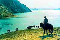
The largest regional river is the Ili River, which flows almost through the center of the Almaty District, dividing it in two parts; in the middle of which the large artificial Kapshagai reservoir has been built, which is defined by its hydroelectric dam. Its length is 815 km within Kazakhstan, and its total length is 1439 km.
Taldykorgan has become the administrative center of the Almaty District, according to the President of the Republic of Kazakhstan's Decree of April 11, 2001 No. 585. The town is located in the southeast of the Republic, below the Northern Zhungar Alalau slopes, 570-630 m above sea level on the bank of the Karatal River. Taldykorgan's history is one of the outstanding stories of the Zhelysu district, (Lavrilovka, a small settlement, was founded on the Tal-Korgan winter pastures in 1868. The beneficial location promoted its quick economic development. There were 586 farms with 4.6 thousand people in Gavrilovka village before World War I. Currently, the town's population has reached 120,000, representing 70 nations and ethnicities. Taldykorgan is one of the greenest cities in Kazakhstan; it is dotted with lush parks and gardens.